Mass Haul & Earthwork Balancing Calculator
Calculate the true volumetric and financial mechanics of moving dirt across your project alignment: from in-situ Bank excavation (BCY) through compaction shrinkage (CCY), net site dirt balance, Free Haul Distance thresholds, overhaul in yard-stations (Sta-Yds), and haul fleet cycle logistics.
What Is a Mass Haul Diagram and How Does an Earthwork Calculator Work?
A Mass Haul Diagram is a continuous graphical curve plotting the cumulative algebraic sum of cut and fill volumes along a linear highway, railway, or civil site alignment. The mass haul calculator determines the net earthwork balance by converting raw cut Bank Cubic Yards (BCY) and fill Compacted Cubic Yards (CCY) using geotechnical shrink/swell factors, establishing balance points where cut equals fill. It computes Free Haul Distance (FHD)—the contractual distance (typically 500 or 1,000 feet) where hauling is included in the base excavation price—and isolates Overhaul in Yard-Stations (Sta-Yds = [Volume (CY) × (Haul Distance − FHD)] / 100) to determine whether hauling site dirt or opening an off-site borrow pit is more economical.
Mass Haul & Earthwork Balancing Calculator
1. Earthwork Volumes & Soil Expansion
2. Haul Distance & Project Specification
Native cut is insufficient. To construct 22,000 CCY of embankment, you must import 882 BCY (750 compacted equivalent) of structural select borrow from off-site pits.
Mass Haul Overhaul Breakdown
OVERHAUL CHARGEABLETrucking Fleet & Cycle Production
20 LCY / TruckDistance between 300 ft and 2,500 ft is prime scraper territory. Scrapers self-load (or push-load), haul, and spread without secondary support equipment.
Engineering Methodology: The Physics of Moving Dirt
In heavy highway, airport, and large commercial site development, an earthwork bid is rarely won or lost solely on the total volume of cut. Profitability hinges on haul distance, haul direction, and material volume transformations.
The Cut-to-Fill Conversion Cycle:
Because compacted embankment requires expelling natural pore spaces to achieve 95% Modified Proctor density, 1,000 BCY of cut will typically yield only 800 to 880 CCY of finished fill. When converting proposed fill back into required cut, you must divide proposed embankment by (1 − Shrinkage Factor).
How Overhaul and Yard-Stations Are Calculated
Standard public works specifications (such as State DOT standard specifications and USACE civil manuals) define two distinct haul zones:
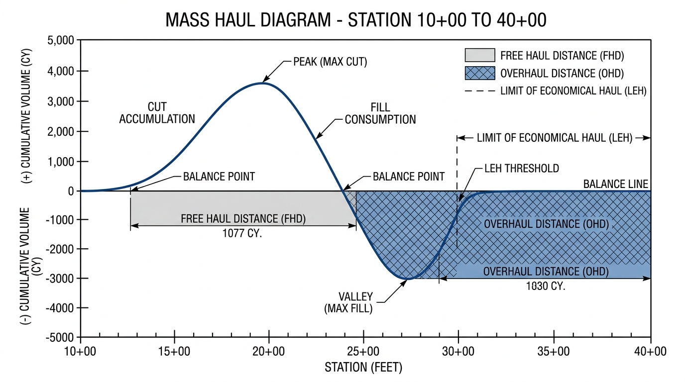
- Free Haul Distance (FHD): The contractual distance (most commonly 500 feet or 1,000 feet) over which the contractor is required to transport excavated material without additional compensation beyond the base unclassified excavation bid item.
- Overhaul Distance: The distance by which the Average Haul Distance (AHD) exceeds the specified Free Haul Distance:Overhaul Distance (ft) = Average Haul Distance (ft) − Free Haul Distance (ft)
- Yard-Station (Sta-Yd): The fundamental engineering unit of overhaul. One Yard-Station represents one cubic yard of dirt hauled one station (100 linear feet) beyond the Free Haul Distance:Overhaul (Sta-Yds) = [Volume Hauled (CY) × Overhaul Distance (ft)] ÷ 100 ft
The Limit of Economical Haul (LEH) & Borrow Economics
A critical decision for chief estimators is determining the point where it becomes cheaper to waste excavated cut on-site and purchase imported borrow from an off-site pit closer to the fill area. This threshold is known as the Limit of Economical Haul (LEH):
For example, if imported select fill costs $12.00 per CY delivered, the overhaul bid item pays $0.30 per Sta-Yd, and the contractual Free Haul Distance is 500 feet (5 stations):
If dirt must be transported further than 4,500 feet along the project alignment, it is mathematically cheaper for the contractor to waste the cut on-site and purchase commercial borrow.
Station-by-Station Mass Haul Worked Example
Consider a 3,000-foot roadway grading alignment from Station 10+00 to Station 40+00:
| Station Interval | Cut Volume (BCY) | Fill Required (CCY) | Fill in Equiv. BCY (15% shrink) | Station Net Balance (BCY) | Cumulative Mass Ordinate (BCY) |
|---|---|---|---|---|---|
| 10+00 to 20+00 | +18,000 BCY | -4,250 CCY | -5,000 BCY | +13,000 BCY (Cut) | +13,000 BCY (Peak) |
| 20+00 to 30+00 | +3,000 BCY | -11,050 CCY | -13,000 BCY | -10,000 BCY (Fill) | +3,000 BCY |
| 30+00 to 40+00 | +2,000 BCY | -4,250 CCY | -5,000 BCY | -3,000 BCY (Fill) | 0 BCY (Balance Point) |
Interpretation of Curve: The cumulative curve peaks at Station 20+00 (+13,000 BCY), indicating the transition from a cut section to a fill section. The curve intersects the zero balance baseline at Station 40+00, proving that all cut excavated between Station 10+00 and 20+00 balances the fill needed between Station 20+00 and 40+00 without off-site borrow or waste. The haul direction is forward (down-station to up-station).
Haul Fleet Selection & Economic Cutoff Distances
Selecting the wrong equipment fleet for a project's haul distance profile is one of the most common causes of contractor liquidation or severe bid losses on earthwork projects:
| Equipment Type | Optimal Haul Distance | Operational Advantage | Limiting Constraints |
|---|---|---|---|
| Crawler Dozers (Push-Dozing) | 0 to 300 Feet | Lowest cost per cubic yard; no loading, spotting, or hauling cycle delay. | Production drops rapidly over 300 ft; excessive blade spillage. |
| Wheel Tractor-Scrapers | 300 to 2,500 Feet | Self-loads (or tandem push-loads), hauls at 25+ mph, and spreads in uniform lifts. | Requires wide, well-maintained haul roads; struggles in rock or saturated muck. |
| Articulated Haul Trucks (CAT 740/745) | 2,500 to 8,000+ Feet | Navigates steep grades, muddy subgrades, and tight turning radii on job sites. | Requires primary excavator loading unit; higher tire and fuel costs. |
| Highway Commercial Dumps (Tri-Axles) | Long Hauls & Off-Site Highway | Legal on public roads; high top speeds for off-site borrow pits and landfills. | Easily bogged down on unfinished off-road grade; slower unloading cycles. |
Frequently Asked Questions (AEO & Heavy Civil Earthmoving)
How does haul road rolling resistance impact cycle times?
Rolling resistance measures the friction between truck tires and unpaved ground. Firm, smooth haul roads have a low 2% rolling resistance factor (40 lbs/ton), while rutted soft mud subgrades can exceed 8% to 12% (160–240 lbs/ton), cutting articulated haul truck speeds in half and doubling equipment cycle times and fuel burn.
Why must fill volumes be converted to equivalent cut volumes before plotting a mass haul curve?
Because soil compacts in the embankment (typically shrinking by 10% to 20% relative to bank cut), 1,000 CCY of fill requires approximately 1,176 BCY of excavation. If raw unadjusted fill CCY is subtracted directly from cut BCY, the mass haul diagram will show a false balance and the project will run out of dirt prematurely in the field.
What is the difference between overhaul and borrow?
Overhaul refers to moving on-site excavated material beyond the contractual Free Haul Distance along the project right-of-way. Borrow refers to purchasing and importing suitable fill material from an off-site commercial quarry or external land parcel when on-site cut is exhausted or exceeds the Limit of Economical Haul.
Connect with Related Civil Estimating Resources
Expand your knowledge and cross-verify your takeoff parameters using our authoritative technical guides and digital modeling services:
- Comprehensive Guide: Read our complete master guide on Mass Haul Diagrams & Earthwork Balancing Mechanics for cumulative yardage curve plotting, balance line placement, and station-by-station borrow math.
- Soil Expansion Guide: Understand laboratory Proctor curves in our Soil Shrink & Swell Conversion Guide (BCY vs. LCY vs. CCY).
- 3D Surface Modeling: Learn how digital terrain models prevent quantity discrepancies in Civil 3D Surface Modeling for Earthwork Takeoffs.
- Commercial Takeoff Service: Explore our professional 3D Earthwork Cut & Fill Takeoff Services to receive full cut/fill color maps, haul summaries, and machine-control surface files.
Need a Detailed Mass Haul Diagram for Your Next Bid?
Upload your grading drawings, existing ground contours, and geotechnical borings. We calculate exact station-by-station mass haul curves, define economic balance lines, and identify every cubic yard of borrow or spoil.