3D Earthwork Cut & Fill Takeoff Services
Eliminate bidding guesswork with digital terrain surface modeling. We provide US excavation contractors, site developers, and general contractors with precise gross and net cut/fill volumes, topsoil stripping analysis, building pad subgrade offsets, and high-visibility 3D elevation heatmaps.
Standard Earthwork Takeoff Scope
- Gross Cut & Gross Fill: In-place bank volume modeling
- Subgrade Section Offsets: Heavy vs light paving, slabs, curb beds
- Topsoil Accounting: 4" to 8" stripping & perimeter respread
- Mass Haul Balancing: Net borrow import vs excess spoil export
- Color Depth Heatmaps: Cut zones (red) vs fill zones (blue)
Direct Technical Summary: What Is a 3D Earthwork Cut and Fill Takeoff?
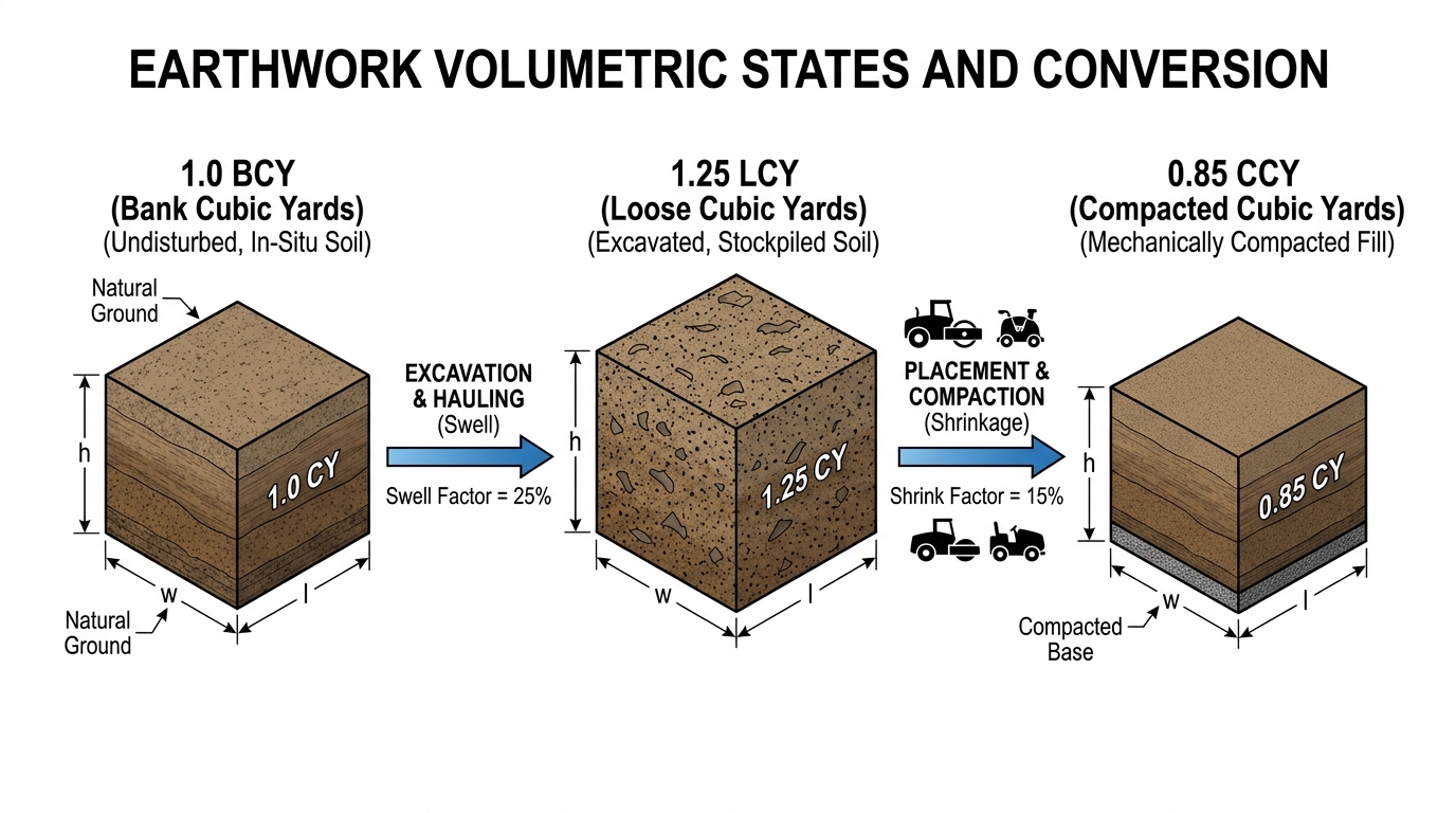
An earthwork cut and fill takeoff is the engineering quantification of all soil, rock, and aggregate volume required to be excavated (cut) or placed (fill) to transform an existing undeveloped topography (EG) into an engineered proposed subgrade design (FG). Professional takeoffs utilize Triangulated Irregular Network (TIN) surface-to-surface prismoidal algorithms to model three separate volumetric states: Bank Cubic Yards (BCY) for in-situ excavation, Loose Cubic Yards (LCY) for truck hauling cycles, and Compacted Cubic Yards (CCY) for structural fill embankment after roller compaction.
How We Construct 3D Digital Terrain Models (DTMs)
Unlike rudimentary 2D takeoffs that merely approximate earth movement using average end area grids or manual digitizer tracing, we construct three independent digital terrain surfaces directly from your engineering CAD and PDF drawing sets:
Surface 1: Existing Topographic Ground Surface (EG)
Constructed from boundary survey contours, LiDAR spot elevations, tree lines, existing roadway centerlines, and ditch flowlines. We apply an engineering topsoil stripping depth (typically 4" to 12" depending on the geotechnical core boring logs) across all disturbed site limits to generate the true bare-earth cut starting plane.
Surface 2: Proposed Design Finished Grade (FG)
Modeled from proposed civil contour lines, building pad finished floor elevations (FFE), curb top-and-gutter breaklines, parking lot high/low drainage points, swales, retention basin berms, and retention pond bottoms.
Surface 3: Engineered Subgrade Surface (FG Subgrade)
The true excavation target plane. We depress the finished grade surface by the precise sectional thickness of all planned structural improvements: heavy-duty asphalt sections (-14.5"), standard car parking (-10.5"), 4" exterior concrete flatwork on 4" base (-8.0"), structural building pads (-12.0" to -24.0" capillary fill), and landscape topsoil respread zones (-4.0").
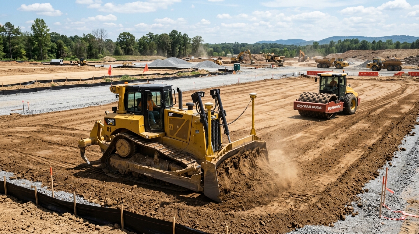
By executing a continuous TIN-to-TIN surface differential between the stripped EG and depressed FG Subgrade, our 3D engine calculates the actual net dirt volume that site scrapers, excavators, and bulldozers must handle—eliminating the severe under-excavation errors typical of manual estimating.
Soil Compaction Dynamics: Shrink, Swell & Mass Haul Balancing
The single most common financial disaster for grading contractors is assuming one yard of in-situ excavation equals one yard of compacted embankment fill. Earth changes physical density and volume through excavation and compaction:
| Soil Material Classification | In-Place (BCY) | Excavated Loose (LCY) | Compacted Embankment (CCY) | Typical Swell % | Typical Shrink % |
|---|---|---|---|---|---|
| Common Earth / Topsoil Loam | 1,000 BCY | 1,250 LCY | 850 CCY | +25% | -15% |
| Dense / Stiff Clay | 1,000 BCY | 1,400 LCY | 800 CCY | +40% | -20% |
| Sand & Coarse Gravel | 1,000 BCY | 1,120 LCY | 920 CCY | +12% | -8% |
| Blasted Solid Rock / Granite | 1,000 BCY | 1,600 LCY | 1,300 CCY | +60% | +30% (Net Expansion) |
Worked Engineering Balance Example:
Assume a commercial logistics warehouse site requires 24,000 CCY of compacted fill embankment across the building footprint, and the grading plan indicates 24,000 BCY of cut from the stormwater basin. If the native material is silty clay exhibiting an 18% compaction shrinkage factor:Available Fill = Cut (BCY) × (1 - Shrink Factor) = 24,000 BCY × (1 - 0.18) = 19,680 CCY
Despite gross quantities appearing equal on paper, the site faces a severe 4,320 CCY shortfall (24,000 - 19,680). At an average imported structural fill cost of $18.50 per cubic yard delivered and placed, an unadjusted takeoff would underestimate the contractor's bid by $79,920. Our takeoffs explicitly identify and calculate these compaction differentials.
Project Sectors We Support
Our civil modeling department provides earthwork takeoffs across all heavy civil, commercial, and residential construction disciplines:
Commercial & Industrial Sites
Retail big-box centers, distribution logistics warehouses, multi-level building pads, loading docks, retention basins, and expansive concrete truck parking aprons.
Residential Subdivisions
Master-planned tract communities, single-family lot grading, detention ponds, arterial roadways, cul-de-sacs, and multi-tier terraced retaining wall pads.
Highways & Heavy Civil
State DOT roadway widenings, highway interchanges, mass haul stationing, cut-to-fill balancing along linear alignments, and borrow pit volume modeling.
Institutional & Energy
Hospitals, university campuses, airport taxiways, solar farm mass grading, substation pads, and industrial rail spur embankments.
Plan Sheets & Engineering Documents Reviewed
To eliminate scope gaps, our estimators cross-reference every sheet in the civil, architectural, and geotechnical bid packages:
- C-100 Topographic Survey & Demolition Plans: Existing spot elevations, benchmark monuments, tree clearing boundaries, and existing asphalt/concrete pavement removal footprints.
- C-200 Civil Site Layout & Dimensioning Plans: Building footprint dimensions, curb geometry, sidewalk alignments, dumpster enclosures, and island configurations.
- C-300 Civil Grading & Drainage Plans: Existing and proposed contours, high points, low points, swale invert elevations, retention basin berm crests, and pond bottoms.
- C-500 Typical Site Sections & Paving Details: Asphalt wearing course thickness, binder course, crushed aggregate base course (ABC), and subgrade stabilization fabrics.
- Geotechnical Engineering & Soil Boring Reports: Boring logs identifying topsoil thickness, groundwater depths, clay plasticity indices, rock refusal elevations, and blow counts (SPT N-values).
- Structural Foundation Sheets (S-Series): SOG slab thickness, capillary crushed stone base, perimeter grade beam depths, and building pad undercut requirements.
QA/QC Verification Protocol for Earthwork Surfaces
A 3D surface model is only as dependable as its boundary controls. Our civil modeling engineers execute a strict four-stage quality assurance process before delivering numbers:
- Boundary Closure & Daylight Audit: We verify that the proposed finished grade surface perfectly ties into existing perimeter elevations along property lines and rights-of-way, confirming zero artificial edge vertical drops or infinite triangles.
- Contour Interpolation & Breakline Check: We audit curb lines, retaining walls, swale centerlines, and building pad corners to verify that breaklines prevent triangular mesh interpolation through vertical grade breaks.
- Unpaver Section Verification: We cross-check every subgrade depression depth against C-500 paving details to ensure heavy-duty asphalt sections (-14") and light-duty sections (-10") do not inadvertently bleed into landscape or sidewalk boundaries.
- Senior Estimator Independent Audit: A senior civil estimator reviews cut/fill balance volumes against historical site benchmarks, verifies topsoil stripping depth, and inspects mass haul movement logistics.
Deliverables Included With Every Earthwork Takeoff
- 3D Color-Coded Cut/Fill Elevation Heatmap (PDF): High-resolution vector map showcasing cut depths in red gradients (0-1', 1-3', 3-5', 5'+), fill depths in blue gradients, and the daylight line.
- Itemized Earthwork Spreadsheet (Excel): Tabulated breakdown of Topsoil Stripping (CY), Topsoil Respread (CY), Rough Cut to Subgrade (BCY), Fill to Subgrade (CCY), Building Pad Over-Excavation (BCY), and Net Site Balance.
- Mass Haul Movement Logistics Summary: Zone-by-zone dirt movement report indicating internal scraper push distances, on-site cut-to-fill distribution, and net export or import quantities.
- Marked-Up Vector Verification Plan: Vector PDF depicting modeled boundary limits, stripping polygons, subgrade depression zones, and sample elevation verification points.
- Machine Control Surface Files (Optional Add-on): Watertight 3D surface terrain files formatted for Trimble (.ttm), Topcon (.tn3), or LandXML (.xml) for contractor GPS-guided dozers and excavators.
Earthwork Takeoff Specifications & Quality Control Matrix
| Takeoff Parameter | Standard Service Specification |
|---|---|
| Measurement Units | Bank Cubic Yards (BCY), Loose Cubic Yards (LCY), Compacted Cubic Yards (CCY), Square Yards (SY), Acre-Feet (AF). |
| Drawings Reviewed | Cover (C000), Existing Topo (C100), Proposed Grading (C200), Civil Details (C500), Structural (S100), and Geotechnical Boring Logs. |
| Specification Alignment | CSI MasterFormat Division 31 10 00 (Site Clearing) & 31 20 00 (Earth Moving). |
| Revisions & Addenda | Revision delta comparison with cloud-marked net cut/fill differential reports for every design addendum. |
| QA/QC Review Protocol | Two-tier peer review: modeler verification followed by senior civil estimator audit checking boundary closure, zero-daylight line, and subgrade unpaver deductions. |
| Standard Exclusions | Building footing excavations (unless structural S-sheets provided), environmental contaminated soil remediation, off-site landfill tipping fees (unless requested). |
Five Costly Earthwork Estimating Mistakes We Prevent
Technical Earthwork Knowledge Base & Contractor Tools
Explore our comprehensive engineering tutorials, contractor decision guides, and interactive tools:
Get an Accurate Earthwork Takeoff Before Bid Day
Send us your grading plans. We will review your drawing set, verify contour legibility, and return a fixed-fee proposal with a guaranteed delivery timeframe.