SITEWORK ESTIMATE
All Estimating Services• 3D Cut & Fill Takeoffs• Site Demolition & Clearing• Underground Utilities (Div 33)• Stormwater & Retention Takeoffs• Site Grading & Asphalt Paving• Concrete Curbs & Flatwork• Erosion Control & SWPPP Takeoffs• Subcontractor Bid Prep
Technical Guides
• Master Sitework Guide• Plan Requirements for Takeoffs• Reviewing a Civil Takeoff• Cut & Fill Math Guide• Utility Trench Takeoffs• Paving & Base Takeoffs• US Soil & Geotech Guide
State & Regional Locations
★ All 50 US States Directory• Texas Civil Estimating• Florida Civil Estimating• California Civil Estimating• Georgia Civil Estimating• Pennsylvania Civil Estimating• New York Civil Estimating
Sample TakeoffsHow It WorksAbout MethodologyContact Desk
Call: +1 (317) 751-5969WhatsApp: +1 (317) 751-5969
Civil Estimating Pillar

The Complete Guide to Civil Sitework Estimating

An authoritative pre-construction engineering manual for excavation contractors, civil general contractors, and estimators. Discover how to transition from 2D civil drawings into mathematically validated, bid-ready 3D earthwork, utility, and paving quantities.

Quick Navigation Guide

1. Why Sitework Estimating is Fundamentally Unique

In architectural and commercial building construction, estimating is largely linear and modular. If a building plan shows 40 pre-hung doors or 1,200 square feet of acoustical ceiling tile, the material counts are unambiguous. The quantities exist in fixed, discrete units.

Sitework is completely different. Civil sitework exists across a continuous, irregular, non-linear three-dimensional terrain. When an excavation contractor bids a civil project, they are bidding on a living geological volume subject to subterranean unknowns, groundwater tables, soil compaction characteristics, and strict storm drainage hydrology.

The 3D Terrain Challenge

Existing natural ground contours rarely align neatly with proposed finished design grades. Calculating the net difference between these surfaces requires integrating thousands of coordinate points via 3D Triangulated Irregular Networks (TIN).

Geotechnical Variabilities

Dirt changes volume depending on its physical state. One cubic yard of undisturbed earth in the ground (Bank Cubic Yards) expands when excavated and shrinks when vibrated into structural fill.
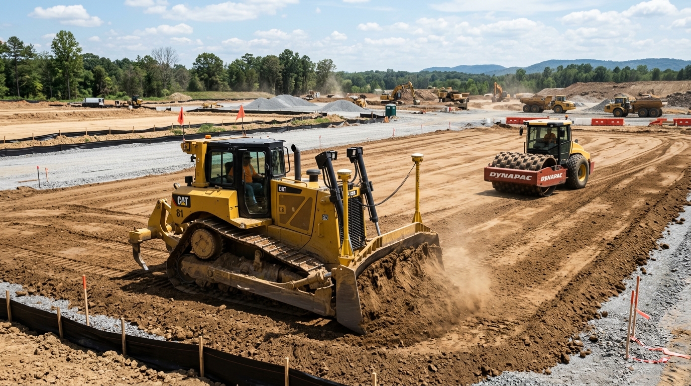
Heavy commercial earthmoving equipment grading a commercial site development pad with dozers and excavators
Field Operations Reality: Transforming 2D engineered blueprints into bulk excavation, structural fill compaction, and subgrade pad prep.

2. The CSI MasterFormat Framework for Civil Sitework

In professional US commercial construction, sitework takeoffs are cataloged under three primary MasterFormat divisions established by the Construction Specifications Institute (CSI):

CSI Division 31: Earthwork

View Division 31 Services →

Encompasses all mass grading, site clearing, organic topsoil stripping, structural building pad cuts, mass fill placement, rock ripping, and subgrade preparation.

Key Takeoff Metrics: Topsoil Stripping (CY), Raw Cut (BCY), Fill Required (CCY), Import/Export Balance, Mass Haul Distance.

CSI Division 32: Exterior Improvements

View Division 32 Services →

Covers vehicular asphalt paving, aggregate base courses, concrete flatwork, dumpster pads, extruded curbs, retaining walls, and perimeter fences.

Key Takeoff Metrics: Subgrade Proof-Roll (SY), Aggregate Base (Tons), Hot Mix Asphalt (Tons via Paving Calculator), Curb & Gutter (LF).

CSI Division 33: Utilities

View Division 33 Services →

Covers all below-grade piping infrastructure: storm water detention, sanitary sewer mains, lateral connections, potable water distribution, valves, hydrants, and electrical/telecom dry duct banks.

Key Takeoff Metrics: Pipe Linear Footage by Depth Bracket (0-6', 6-10', 10-14', 14'+), Trench Excavation (CY), Pipe Bedding (#57 stone via Trench Calculator), Manholes & Inlets (EA).

3. The 5-Stage Sitework Takeoff Methodology

To produce accurate civil takeoffs that win bids without leaving money on the table, professional estimators follow a disciplined 5-stage workflow:

Stage 1: Document Scrutiny & Scale Calibration

Before tracing a single line, verify the drawing scale. Civil drawings are frequently printed at reduced scale (e.g., 11"×17" half-size sets of a 22"×34" full-size drawing). Always calibrate using the graphic bar scale on the sheet rather than relying on the printed numerical text scale (e.g. 1" = 20'). Cross-reference the geotechnical boring logs to identify groundwater depth, topsoil stripping depths, and rock strata refusal elevations.

Stage 2: 3D Surface Modeling (Existing vs. Proposed Contours)

Import digital vector CAD drawings or trace high-resolution PDF contours to generate two independent surfaces: the Existing Ground TIN and the Proposed Finished Design TIN. Apply subgrade section offsets across building pads, parking lots, and sidewalks to calculate true excavation subgrades rather than raw finished surface grades.

Stage 3: Underground Utility Trenching & Structure Schedules

Trace pipe centerlines from plan & profile sheets. Measure station-to-station runs, calculate average rim-to-invert depths, categorize runs into depth brackets, and calculate required bedding stone envelopes while subtracting pipe barrel displacement.

Stage 4: Pavement Sections & Linear Curb Profiles

Extract surface area for heavy-duty vehicular paving (truck courts, loading docks) and light-duty passenger car stalls. Convert compacted depths into quarry tonnages using industry bulk density constants (112 lbs/sy-in for asphalt, 2.05 tons/cy for stone base).

Stage 5: Quality Audit & Discrepancy Reconciliation

Run pre-bid audits against our 28-Point Pre-Bid Checklist. Check for conflicts between civil grading elevations and architectural finished floor elevations (FFEs), identify missing utility tie-in invert data, and package deliverables into itemized Excel bid sheets.

4. High-Risk Pitfalls That Burn Contractor Profits

Civil contractors go out of business far more often from estimating errors than from field equipment breakdowns. The three most common mathematical errors are:

Pitfall 1: Forgetting the Subgrade Section Offset

If an estimator cuts a 100,000 SF parking lot directly to finished grade contours without deducting the 12" combined pavement section (3" asphalt + 9" aggregate base), they will overestimate on-site cut by over 3,700 cubic yards. In the field, the excavator will overcut the site, requiring thousands of tons of expensive imported fill to bring the subgrade back up to design tolerance.

Pitfall 2: Confusing BCY with LCY in Trucking Budgets

Excavators dig Bank Cubic Yards (in-situ dirt). However, once loaded into a dump truck, soil expands by 15% to 40% (Loose Cubic Yards). If a site requires exporting 10,000 BCY of dense clay (30% swell) and the estimator prices hauling based on 10,000 yards, they will be short by 3,000 truck yards (nearly 190 tri-axle truckloads) of trucking costs.

Pitfall 3: Ignoring Regional Soil Mechanics

Pricing dirt excavation identically across different states is catastrophic. In North Texas, high plasticity index clays require lime stabilization; in Florida, high water tables demand continuous wellpointing; in the Midwest, frost lines reach 48". Review our US Regional Geotechnical Guide before bidding projects out of your primary territory.

5. Specialized Civil Estimating Guides & Methodologies

Deepen your team's estimating precision with our technical step-by-step guides covering each specialized trade of the civil sitework envelope:

Reading Civil Plans for Sitework Takeoffs →

Sheet index navigation, contour interpolation, boundary limits, and finding hidden subgrade elevations.

Soil Shrink & Swell Volumetrics →

Bank Cubic Yards (BCY), Loose Cubic Yards (LCY), and Compacted Cubic Yards (CCY) formulas and truckload math.

Rock Excavation: Rippable vs. Blasting →

Seismic velocity tables, RQD interpretation, mass rock cuts, and confined utility trench rock pricing.

Waterline & Sanitary Sewer Takeoffs →

Pipe counting, trench depth classification, stone bedding, pipe displacement, and manhole assemblies.

Stormwater Retention & Detention Basins →

Basin side-slope staging, clay liner square footage, riprap spillways, and multi-stage concrete weir outfalls.

Underground Stormwater Detention →

Plastic chamber takeoffs (StormTech), stone embedment tonnage, geotextile wrap, and manifold piping.

Concrete Curb, Gutter & Sidewalks →

Linear feet to ready-mix cubic yards, flatwork thickness conversion, dumpster aprons, and ADA curb ramps.

SWPPP & Erosion Control Takeoffs →

Tracking pad stone tonnage, perimeter silt fence, inlet sacks, and slope erosion control blankets (ECB/TRM).

Site Clearing & Demolition Takeoffs →

Clearing acreage, root grubbing, asphalt/concrete demolition tonnage, and sawcutting linear footage.

Sitework Scope Gap Analysis →

Preventing bidding omissions between civil, MEP, and structural sheets, proposal exclusions, and bid leveling.

Civil 3D Surface Modeling →

Triangulated Irregular Network (TIN) geometry, 3D breaklines, boundary clipping, and subgrade elevation offsets.

3D Machine Control Grading Models →

LandXML, Trimble (.ttm), and Topcon (.tn3) file preparation, contour smoothing, and machine elevation QA/QC.

Mass Haul Diagrams & Earthwork Balancing →

Cumulative volume curves, balance lines, free haul vs overhaul distance, and heavy earthmoving fleet selection.

Construction Dewatering & Groundwater →

High water tables, wellpoint arrays, open sump pits, sediment filtration bags, and environmental discharge permits.

Why Earthwork Quantities Differ →

Subgrade deductions, stripping depth variances, boundary limits, and TIN vs grid volumetric algorithm differences.

Civil Takeoff QA/QC Audit Protocol →

Chief estimator review framework, zero-spike filtering, utility slope checks, and paving tonnage sanity formulas.

Plan Revisions & Addenda Takeoffs →

Digital PDF delta overlays, tracking revision clouds, quantifying grading shifts, and formatting addenda logs.

Need Precision Sitework Takeoffs for an Upcoming Bid?

Sitework Estimate provides turn-key 3D cut/fill modeling, underground utility schedules, and itemized CSI Excel bid sheets for general contractors and civil trade subcontractors across the United States.

Inspect Sample 3D Deliverables