Earthwork Volume Calculator: BCY, LCY & CCY Conversion
Accurately model volumetric soil phase transitions across excavation, off-site hauling, and structural embankment compaction. Convert in-situ Bank Cubic Yards (BCY) to Loose Cubic Yards (LCY) for haul fleet scheduling and Compacted Cubic Yards (CCY) for mass fill placement.
What Is the Difference Between BCY, LCY, and CCY in Earthwork Estimating?
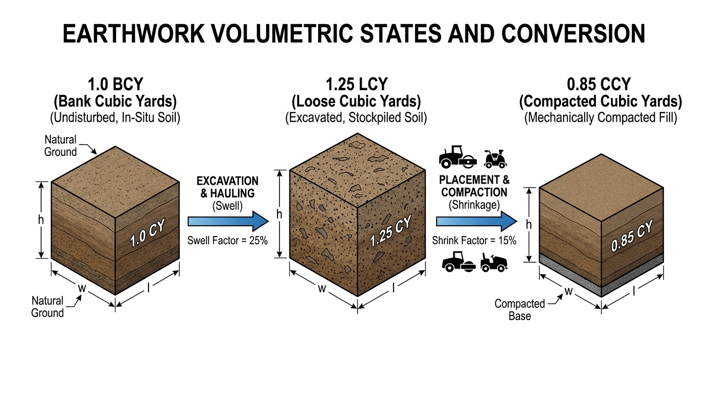
In civil sitework estimating, soil exists in three distinct physical states governed by density and void ratios: Bank Cubic Yards (BCY) represents undisturbed in-situ earth in its natural geological state before excavation; Loose Cubic Yards (LCY) represents excavated earth that has expanded with entrained air, creating soil swell that dictates haul truck bed capacity; and Compacted Cubic Yards (CCY) represents fill material rolled into embankment lifts to specified Modified Proctor densities (ASTM D1557), where mechanical compaction expels air and creates volumetric shrinkage relative to the bank state.
Project Earthwork Parameters
Calculated Soil Volumes
LIVE CONVERSIONSMathematical Principles of Soil Phase Changes
In heavy civil construction, failure to account for geotechnical volume changes represents the leading cause of subcontractor bid day margin erosion and unrecoverable trucking cost overruns. Soil volume is not static; it changes dynamically across each phase of the earthmoving lifecycle.
1. The Three Physical States of Earthwork Materials
Bank State (BCY)
Natural undisturbed earth. Civil engineer cross-sections, digital surface terrain models (DTM), and plan grading contours always quantify cut volumes in BCY.
Loose State (LCY)
Excavated material disturbed by bucket teeth and scrapers. Entrained air voids increase volume by 10% to 50% (swell factor), determining required truck counts.
Compacted State (CCY)
Material spread in 8-inch to 12-inch loose lifts and rolled to specified dry density. Voids are eliminated, resulting in a volume 8% to 25% smaller than the original bank cut.
Governing Earthwork Formulas
Professional sitework estimators utilize standardized geotechnical equations derived from soil weight-volume relationships to convert between raw blueprint yardages and bid-day trucking sheets.
Core Geotechnical Volume Conversions
- Loose Volume (LCY): LCY = BCY × (1 + Swell Percentage / 100)
- Compacted Volume (CCY): CCY = BCY × (1 - Shrinkage Percentage / 100)
- Compaction Factor (Cf): Cf = CCY / BCY = (1 - Shrinkage Percentage / 100)
- Bank Required for Fill: Required BCY = Target CCY / Cf = Target CCY / (1 - Shrinkage)
- Truckload Haul Trips: Trips = Total LCY / Rated Struck Capacity of Haul Fleet
Representative Soil Swell & Shrink Factors
Every soil stratum exhibits unique void ratio changes based on grain size distribution, plasticity index (PI), and initial natural moisture content. The table below outlines typical ranges specified across US DOT and ASTM geotechnical engineering standards:
| Soil Material Classification | In-Situ Bank Density (lbs/BCY) | Volumetric Swell (%) | Net Shrinkage (%) | Compaction Factor (Cf) |
|---|---|---|---|---|
| Clean Sand / Gravel (Well-Graded) | 2,700 – 3,100 | 10% – 15% | 8% – 12% | 0.88 – 0.92 |
| Common Earth / Sandy Clay (Loam) | 2,400 – 2,800 | 20% – 25% | 12% – 16% | 0.84 – 0.88 |
| Dense Stiff Clay (High Plasticity) | 2,700 – 3,200 | 30% – 38% | 18% – 22% | 0.78 – 0.82 |
| Glacial Till / Hardpan | 3,000 – 3,500 | 25% – 35% | 15% – 20% | 0.80 – 0.85 |
| Solid Limestone / Blasted Rock | 4,000 – 4,800 | 50% – 65% | -20% to -40% (Expands) | 1.20 – 1.40 |
Note: Blasted solid rock exhibits negative shrinkage because fractured rock fragments can never be recompacted back to the original consolidated density of in-situ bedrock, resulting in an embankment volume greater than the cut volume. Always cross-reference your specific project’s geotechnical boring log report.
Step-by-Step Worked Estimating Example
Consider a 12-acre commercial logistics distribution center project with the following raw digital terrain surface takeoff numbers calculated in civil CAD software:
- Raw On-Site Cut: 45,000 BCY (Classified as Common Clayey Sand with 25% Swell and 15% Shrink)
- Engineered Embankment Fill Required: 38,000 CCY under building pad and parking areas
- Haul Fleet Configuration: Tri-axle dump trucks with 16 LCY practical struck capacity
Step 1: Calculate On-Site Soil Cut Available for Embankment
Using the compaction factor for common earth (Cf = 1 - 0.15 = 0.85):
Fill Yield from Cut = 45,000 BCY × 0.85 = 38,250 CCY
Step 2: Determine Net Dirt Balance (Import vs. Export)
Net Balance = 38,250 CCY available - 38,000 CCY required = +250 CCY Surplus
The site is effectively balanced with a nominal 250 CCY surplus to be respread or wasted on site.
Step 3: Calculate Total Haul Volume & Truck Trips If Soil Must Be Relocated
If 10,000 BCY of the cut must be hauled across an arterial roadway to an off-site spoil area:
Loose Haul Volume = 10,000 BCY × (1 + 0.25) = 12,500 LCY
Required Truckloads = 12,500 LCY / 16 LCY per truck = 782 Haul Trips
Common Field Pitfalls & Earthwork Estimating Errors
1. Treating 1 CY of Cut Equal to 1 CY of Fill
Bidding an earthwork project on a 1:1 ratio between cut and fill ignores soil compaction shrinkage. A site that appears balanced on 2D plans will experience a major borrow dirt deficit once rolled to 95% Modified Proctor density.
2. Ignoring Topsoil Stripping in Dirt Balance
Stripping 6 to 12 inches of organic topsoil lowers the existing ground surface prior to bulk cut/fill operations. If stripping depth is not deducted from the 3D surface, fill requirements will be severely underestimated.
3. Using Struck Bed Volume for Trucking Weight Limits
While loose soil expands in volume, wet dense clay may exceed legal highway axle weight limits before the dump truck bed is volumetrically full. Always check state DOT gross vehicle weight limits (typically 80,000 lbs).
4. Over-Excavating Building Pads Without Pay Item Credit
Structural specifications often mandate a 2-foot to 5-foot over-excavation and moisture conditioning beneath foundation slabs. If not modeled as a distinct subgrade zone, thousands of cubic yards of imported select fill will be missed.
Frequently Asked Questions (AEO & Engineering Clarifications)
How do geotechnical boring logs define soil swell and shrink?
Geotechnical reports provide natural dry density (pcf), moisture content, and laboratory Modified Proctor maximum dry density (ASTM D1557). Estimators divide the in-situ dry density by the maximum compacted dry density to determine the exact shrinkage ratio (Compaction Factor = Dry Density Bank / Dry Density Compacted).
Does soil swell affect the excavation production rate of heavy equipment?
Yes. Excavator buckets and scraper bowls fill in loose cubic yards (LCY). High-swell soils fill bucket volume faster but with lower density, while dense rock requires ripping before loading, reducing hourly cycle productivity by 20% to 40%.
What is the difference between standard proctor and modified proctor?
Standard Proctor (ASTM D698) applies approximately 12,400 ft-lbf/cu.ft of compaction effort, representing lighter residential loading. Modified Proctor (ASTM D1557) applies 56,250 ft-lbf/cu.ft—over 4.5 times more energy—representing heavy highway, airport, and industrial warehouse pavement subgrades. Higher compaction energy results in greater soil shrinkage.
How do estimators connect soil volume calculations to mass haul diagrams?
Mass haul diagrams plot station-by-station algebraic cumulative cut and fill. However, before plotting, all fill embankment CCY values must be converted back to equivalent BCY (or cut BCY adjusted to net compacted volume) so that the balance line accurately reflects mass balance points. Explore our interactive Mass Haul Diagram Calculator to model project haul balances.
Related Earthwork Services & Technical Guides
Deepen your civil preconstruction knowledge or explore professional quantity takeoff deliverables:
3D Earthwork Cut & Fill Takeoff Services
Professional surface-to-surface digital elevation modeling, 3D cut/fill heatmaps, building pad subgrade offsets, and itemized CSI MasterFormat bid sheets.
ENGINEERING GUIDESoil Shrink & Swell Geotechnical Guide
Detailed breakdown of Atterberg limits, plasticity index (PI), and geotechnical laboratory proctor testing for civil estimators.
Need Complete 3D Terrain Modeling for Your Next Bid?
Send us your civil blueprint drawings. Our senior estimating team builds watertight 3D TIN surfaces, calculates pad depressions, and delivers verified dirt balance packages within 24 to 48 hours.